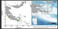
Christmas island3, the largest atoll in the world in terms of
subaerial surface area, is located 200 km north of the equator in the equatorial dry zone (Schott, 1933). The atoll is influenced by nearly constant 4 m/sec easterly winds and an average annual precipitation of 873 mm unevenly distributed in time (Jenkin and Foale, 1968). The shape of this southernmost of the northern Line Islands is like an elongated lobster claw with pinchers open to the northwest containing a semi-circular lagoon. Two passes, each nearly 2 km wide, connect the main lagoon to the ocean. Numerous subrectangular shaped hypersaline lakes are found to the east of the main lagoon as well as centrally along the elongated "am" which extends 18 km to the southeast. Along the southeastern margin of the lagoon, the lakes are more numerous, and narrow channels connect some of them to the lagoon.
Available online
Call Number: [EL]
Physical Description: 19 p.
Publication