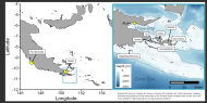
Digital Elevation Model and Hillshade - United States Geological Survey
A 10-meter resolution land surface digital elevation model (DEM) and derived hillshade for the islands of Palau from United States Geological Survey (USGS) 1/3 arc-second DEM quadrangles.