  • SPREP Home
  • Protected Areas
SPREP Home
Log in
Search
Home | PIPAP - Supporting the sustainable management of protected areas in the Pacific Region.
  • Data
    • Protected Areas
    • Management Effectiveness Dashboard
    • Spatial Data
  • Assistance
    • How SPREP Helps
    • WDPA Protected Area Registration
    • Protected Area Working Group
  • Resource Hub
    • Publications
    • Decision Making Support Tools
    • Case Studies
  • Newsletter
    • Browse Newsletter Archive
    • Subscribe Now
  • Account
    • Login

Main menu

  • Data
  • Assistance
  • Resource Hub
  • Newsletter
  • Account

Breadcrumb

  1. Home
  2. Resource Hub
  3. Publications

General Bathymetric Chart of the Oceans (GEBCO)

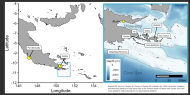
The General Bathymetric Chart of the Oceans (GEBCO) aims to provide the most authoritative, publicly-available bathymetry data sets for the world’s oceans.

Links
General Bathymetric Chart of the Oceans (GEBCO)
Publication
Related page category(s)
Marine Resources
Related Pages
Biological Surveys of Carondelet, a Shallow, Submerged Seamount in the Phoenix Islands, Kiribati
Sustainable Finance for Asia and the Pacific: Protecting and Restoring Coral Reefs
High Seas Biodiversity Treaty Policy Brief
Video - Introduction to SPREP's Regional Marine Species Programme
Best practice guidelines for mangrove restoration
Video - Long Story Shorts: Why Should You Care about Deep-Sea Mining?
Priority areas to protect mangroves and maximise ecosystem services
The Marine Spatial Planning Index: a tool to guide and assess marine spatial planning
Sea Turtle Monitoring Manual
Quantifying longline bycatch mortality for pelagic sharks in western Pacific shark sanctuaries

Latest News

SPC
Bezos Earth Fund Invests $37.5M USD to Accelerate Pacific-Led Ocean…
September 17, 2025 by Isaac Rounds
Read More
WCS/Solomon Islands
Solomon Islands to Protect Up to 24 Million Hectares of Ocean With Support…
September 17, 2025 by Isaac Rounds
Read More
PNG
Communities in New Ireland Province, Papua New Guinea, take ownership in…
September 16, 2025 by Isaac Rounds
Read More
SPREP
Request for Tenders: Review and Update of the Pacific Island…
September 15, 2025 by Isaac Rounds
Read More

Latest Resources

Terrestrial Biodiversity of Manuae Atoll, Cook Islands
September 15, 2025 by Isaac Rounds
Read More
Biology and Impacts of Pacific Island Invasive Species. 17. Lissachatina…
September 15, 2025 by Isaac Rounds
Read More
Blue Prosperity Vanuatu FINAL SCIENCE REPORT
September 15, 2025 by Isaac Rounds
Read More
Blue Prosperity Vanuatu 2023 Coral Reef Study Preliminary Science Report
September 15, 2025 by Isaac Rounds
Read More
Biodiversity and Protected Areas Management Programme Logo Organisation of African, Caribbean and Pacific States Logo Sprep BioScapes Logo Flag of European Union International Union for Conservation of Nature Logo European Commission Logo

SPREP Footer Logo

A resilient Pacific environment sustaining our livelihoods and natural heritage in harmony with our cultures.

+685 21929
[email protected]

  • SPREP on Facebook
  • SPREP on YouTube
  • SPREP on Twitter
Protected Areas by Country
  • American Samoa
  • Cook Islands
  • Fiji
  • French Polynesia
  • Guam
  • Kiribati
  • Marshall Islands
  • Micronesia (Federated States of)
  • Nauru
  • New Caledonia
  • Niue
  • Northern Mariana Islands
  • Palau
  • Papua New Guinea
  • Samoa
  • Solomon Islands
  • Timor-Leste
  • Tokelau
  • Tonga
  • Tuvalu
  • Vanuatu
  • Wallis and Futuna
SPREP © 2025. All rights reserved.