  • SPREP Home
  • Protected Areas
SPREP Home
Log in
Search
Home | PIPAP - Supporting the sustainable management of protected areas in the Pacific Region.
  • Data
    • Protected Areas
    • Management Effectiveness Dashboard
    • Spatial Data
  • Assistance
    • How SPREP Helps
    • WDPA Protected Area Registration
    • Protected Area Working Group
  • Resource Hub
    • Publications
    • Decision Making Support Tools
    • Case Studies
  • Newsletter
    • Browse Newsletter Archive
    • Subscribe Now
  • Account
    • Login

Main menu

  • Data
  • Assistance
  • Resource Hub
  • Newsletter
  • Account

Breadcrumb

Home

An artist’s rendering of Landsat 8. Credit: NASA/Goddard Space Flight Center Conceptual Image Lab
Landsat at 50: How satellites revolutionized the way we see, and protect, the natural world
September 26, 2022

Fifty years ago, U.S. scientists launched a satellite that dramatically changed how we see the world.

  • Read more about Landsat at 50: How satellites revolutionized the way we see, and protect, the natural world
The government and fishermen of Palau are setting up sustainable aquaculture farms near their shores in an effort to ensure food security for generations to come. Their planning work uses information from NASA's satellites to protect the country’s rich ecosystems. Credit: Courtesy of Fabio Siksei
NASA satellites help plan future for Palau fish stocks
August 6, 2021

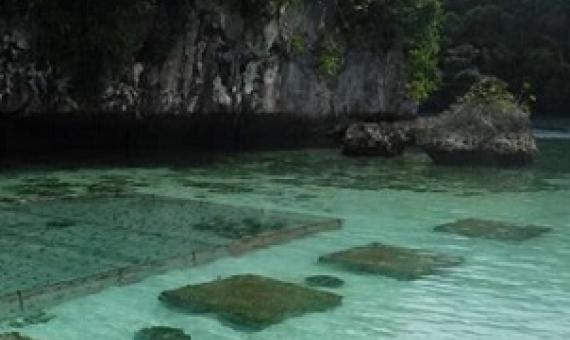
People in Palau, a small nation with a population of about 20,000, consume more wild fish per capita than nearly any other country in the world.

  • Read more about NASA satellites help plan future for Palau fish stocks
The Amazon rainforest is often called "the lungs of the world." It produces oxygen and stores billions of tons of carbon every year. The Amazon rainforest covers more than 60% of the landmass of Peru. Credit: USDA Forest Service photo by Diego Perez
NASA study finds tropical forests' ability to absorb carbon dioxide is waning
July 23, 2021

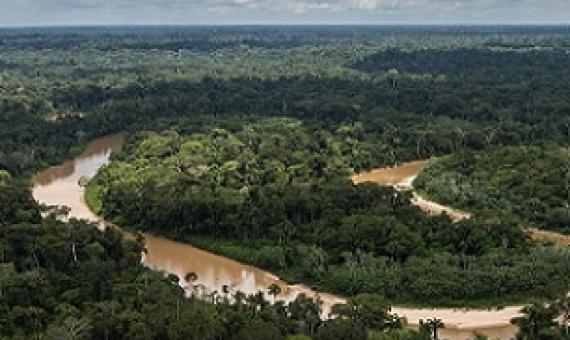
The finding comes out of an effort to map where vegetation is emitting and soaking up carbon dioxide from the atmosphere...The research found that over the course of those two decades, living woody plants were responsible for more than 80% of the sources and sinks on land, with soil, leaf litter,

  • Read more about NASA study finds tropical forests' ability to absorb carbon dioxide is waning
The sun rises over a neighborhood in Encinitas, California, amid a heatwave last year. Photograph: Mike Blake/Reuters
Earth is trapping ‘unprecedented’ amount of heat, Nasa says
June 24, 2021

The Earth is trapping nearly twice as much heat as it did in 2005, according to new research, described as an “unprecedented” increase amid the climate crisis.

  • Read more about Earth is trapping ‘unprecedented’ amount of heat, Nasa says
coral reefs. Credit - mongabay.com
Guam featured in NASA game to help coral reefs
March 19, 2021

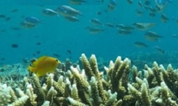
Guam is featured in a game developed by NASA to help coral reefs around the world...NeMO-Net is a coral classification game that lets you embark on a virtual research vessel and travel the oceans, analyzing actual images of corals on the sea floor.

  • Read more about Guam featured in NASA game to help coral reefs
NASA logo
Remote Sensing of Coastal Ecosystems
August 14, 2020

Remote sensing of coastal and marine ecosystems is particularly challenging.

  • Read more about Remote Sensing of Coastal Ecosystems
When it comes to water, think globally
April 24, 2020

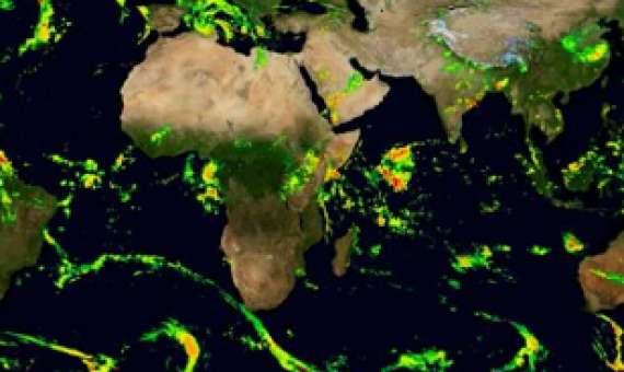
Earth is a pale, blue dot when seen from space. Its blue color is due to our home planet being 71% covered in water. NASA monitors Earth's water from space, the skies, ground stations on land, ships sailing the seas and even with apps on mobile phones.

  • Read more about When it comes to water, think globally
Biodiversity and Protected Areas Management Programme Logo Organisation of African, Caribbean and Pacific States Logo Sprep BioScapes Logo Flag of European Union International Union for Conservation of Nature Logo European Commission Logo

SPREP Footer Logo

A resilient Pacific environment sustaining our livelihoods and natural heritage in harmony with our cultures.

+685 21929
[email protected]

  • SPREP on Facebook
  • SPREP on YouTube
  • SPREP on Twitter
Protected Areas by Country
  • American Samoa
  • Cook Islands
  • Fiji
  • French Polynesia
  • Guam
  • Kiribati
  • Marshall Islands
  • Micronesia (Federated States of)
  • Nauru
  • New Caledonia
  • Niue
  • Northern Mariana Islands
  • Palau
  • Papua New Guinea
  • Samoa
  • Solomon Islands
  • Timor-Leste
  • Tokelau
  • Tonga
  • Tuvalu
  • Vanuatu
  • Wallis and Futuna
SPREP © 2025. All rights reserved.