  • SPREP Home
  • Protected Areas
SPREP Home
Log in
Search
Home | PIPAP - Supporting the sustainable management of protected areas in the Pacific Region.
  • Data
    • Protected Areas
    • Management Effectiveness Dashboard
    • Spatial Data
  • Assistance
    • How SPREP Helps
    • WDPA Protected Area Registration
    • Protected Area Working Group
  • Resource Hub
    • Publications
    • Decision Making Support Tools
    • Case Studies
  • Newsletter
    • Browse Newsletter Archive
    • Subscribe Now
  • Account
    • Login

Main menu

  • Data
  • Assistance
  • Resource Hub
  • Newsletter
  • Account

Breadcrumb

Home

Credit - Global Fishing Watch
These Satellite Maps Reveal Rampant Fishing by Untracked ‘Dark Vessels’ in the World’s Oceans
January 12, 2024

For the first time ever, researchers have created a global map of human activity in the oceans and on coastlines, published last week in the journal Nature.

  • Read more about These Satellite Maps Reveal Rampant Fishing by Untracked ‘Dark Vessels’ in the World’s Oceans
Over 8,000 satellites are orbiting Earth today, capturing images like this, of the Louisiana coast. Credit: NASA Earth Observatory
How to use free satellite data to monitor natural disasters and environmental changes
March 16, 2023

If you want to track changes in the Amazon rainforest, see the full expanse of a hurricane or figure out where people need help after a disaster, it's much easier to do with the view from a satellite orbiting a few hundred miles above Earth.

  • Read more about How to use free satellite data to monitor natural disasters and environmental changes
An artist’s rendering of Landsat 8. Credit: NASA/Goddard Space Flight Center Conceptual Image Lab
Landsat at 50: How satellites revolutionized the way we see, and protect, the natural world
September 26, 2022

Fifty years ago, U.S. scientists launched a satellite that dramatically changed how we see the world.

  • Read more about Landsat at 50: How satellites revolutionized the way we see, and protect, the natural world
Plant species diversity in four different ecosystems represented as spectral variation. Credit: Anna Schweiger, Etienne Laliberté
Satellite monitoring of biodiversity moves within reach
May 21, 2022

Global biodiversity assessments require the collection of data on changes in plant biodiversity on an ongoing basis.

  • Read more about Satellite monitoring of biodiversity moves within reach
forest protected area
New measure of tropical forest vulnerability to help avoid 'tipping point'
July 29, 2021

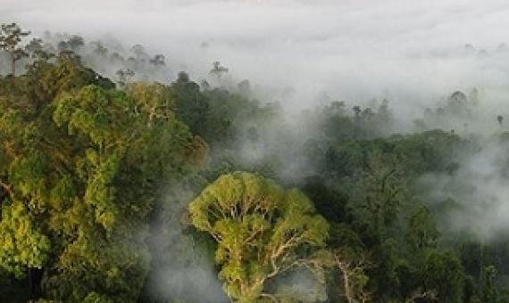
Humid tropical forests, vital in global efforts to limit rising temperatures, are under threat as a result of changes in land use and climate.

  • Read more about New measure of tropical forest vulnerability to help avoid 'tipping point'
Lifting the clouds on land clearing and biodiversity loss. Credit: Pixabay/CC0 Public Domain
Lifting the clouds on land clearing and biodiversity loss
July 1, 2021

QUT researchers have developed a new machine learning mathematical system that helps to identify and detect changes in biodiversity, including land clearing, when satellite imagery is obstructed by clouds.

  • Read more about Lifting the clouds on land clearing and biodiversity loss
Biodiversity and Protected Areas Management Programme Logo Organisation of African, Caribbean and Pacific States Logo Sprep BioScapes Logo Flag of European Union International Union for Conservation of Nature Logo European Commission Logo

SPREP Footer Logo

A resilient Pacific environment sustaining our livelihoods and natural heritage in harmony with our cultures.

+685 21929
[email protected]

  • SPREP on Facebook
  • SPREP on YouTube
  • SPREP on Twitter
Protected Areas by Country
  • American Samoa
  • Cook Islands
  • Fiji
  • French Polynesia
  • Guam
  • Kiribati
  • Marshall Islands
  • Micronesia (Federated States of)
  • Nauru
  • New Caledonia
  • Niue
  • Northern Mariana Islands
  • Palau
  • Papua New Guinea
  • Samoa
  • Solomon Islands
  • Timor-Leste
  • Tokelau
  • Tonga
  • Tuvalu
  • Vanuatu
  • Wallis and Futuna
SPREP © 2025. All rights reserved.