Mangrove ecosystems play a critical role in harbouring biodiversity and providing a variety of ecosystem services. The need for developing better techniques for classifying and monitoring mangroves is increasing, especially with the growing demand in blue carbon markets. However, many countries are challenged by the need to improve their mangrove cover estimates to inform decision-making on coastal land use and to guide local conservation efforts including restoration planning. This manual was developed to help overcome this problem by providing guidance, specifically targeted to build capacity for mangrove resource managers on how to use and take advantage of the latest technologies in mapping and monitoring mangroves. It enables collection of data that informs conservation decision-making, guiding the planning of mangrove restoration and protection activities that will ultimately lead to enhanced management and conservation of mangroves. In addition, case studies are presented on estimating mangrove extent, structure, condition and change, using a range of remote sensing-derived sources that are focused on < 5-m spatial resolution.
Ecological and Socioeconomic Vulnerability and Opportunities Assessment (ESVOA), Tenmaru, Malekula
he objective of an Ecosystem and Socio-economic Resilience Analysis and Mapping (ESRAM) process is to generate a robust planning baseline to inform the identification of ecosystem-based adaptation (EbA) options for strengthening the socio-ecological resilience of communities to the impacts of cli
Ecological and Socioeconomic Vulnerability and Opportunities Assessment (ESVOA), Wiawi, Malekula.
The objective of an Integrated Ecosystem Management Plan process is to generate a robust planning baseline to inform the identification of ecosystem-based adaptation (EbA) options for strengthening the socio-ecological resilience of communities to the impacts of climate change and other direct an
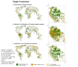
Ecological Constraints on Tropical Forest Recovery Challenge the “Long-Term” Vision of the Kunming–Montreal Global Biodiversity Framework

The Kunming–Montreal Global Biodiversity Framework (GBF) outlines targets for protecting and restoring biodiversity by 2030, with the vision of “living in harmony with nature” by 2050.
Ecological functional diversity predicts nutritional functional diversity in complex agroforests
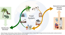
Biodiversity loss and rising noncommunicable disease incidences are among the greatest global challenges we face.
Ecosystem and Socio-Economic Resilience Analysis and Mapping (ESRAM) : Solomon Islands, Vol 3 : Honiara
This report Volume 3 (of three volumes) prepared as part of the Solomon Islands Ecosystems and Socio-economic Resilience Analysis and Mapping (ESRAM) to assess and priortise climate change-related ecosystem-based adaptaton options for selected locations in Solomon Islands.
Ecosystem and socio-economic resilience analysis and mapping (ESRAM) : Solomon Islands, Volume 1 : introduction and national assessment
This report presents Volume 1 (of three volumes) prepared as part of the Solomon Islands Ecosystems and Socio-economic Resilience Analysis and Mapping (ESRAM) to assess and prioritise climate change-related ecosystem-based adapation options for selected locations in Solomon Islands.
Ecosystem and socio-economic resilience analysis and mapping (ESRAM) : Solomon Islands, Volume 2 : Wagina Island (Choiseul Province)
This report presents Volume 2 (of three volumes) prepared as part of the Solomon Islands Ecosystems and Socio-economic Resilience Analysis and Mapping (ESRAM) to assess and climate change-related ecosystem-based adaptation (EbA) options in Solomon Islands.
Ecosystem and Socio-economic Resilience Analysis and Mapping (ESRAM) for Central Islands Province, Solomon Islands
The target area for the ESRAM assessment is the land- and seascape comprising Nggela Islands, Russell Islands and Savo Island. This is largely due to the very high biodiversity values of their terrestrial and marine areas.
Ecosystem and Socio-economic Resilience Analysis and Mapping (ESRAM) for three Communities of Southern Malaita & Maramasike Passage, Solomon Islands : Summary Report
This report presents a summary of an Ecosystem and Socio-economic Resilience Analysis and Mapping (ESRAM) project in three communities in South Malaita, Malaita Province in the Solomon Islands; Tapa'atewa, Eliote and Ori Pre.
Ecosystem and socio-economic resilience analysis and mapping Macuata Province Fiji
The ecosystem and socio-economic resilience analysis and mapping (ESRAM) is a baseline study to identify vulnerabilities in ecosystem services at national, provincial and community scales in Fiji.
Ecosystem and socio-economic resilience analysis and mapping Taveuni Island, Fiji
The ecosystem and socio-economic resilience analysis and mapping (ESRAM) is a baseline study to identify vulnerabilities in ecosystem services at national, provincial and community scales in Fiji.
Ecosystem and Socioeconomic Resilience Analysis and Mapping Navua catchment and Beqa lagoon 2024
This report presents the Ecosystem and Socioeconomic Resilience Analysis and Mapping (ESRAM) prepared as part of Objective 4. ESRAM is a framework employed globally to evaluate and strengthen the resilience of both, natural ecosystems and the socioeconomic systems closely linked to them.
Ecosystem-based adaptation options assessment - Macuata province Fiji
This project identifies two Ecosystem-based Adaptation (EbA) options that are organisational tools to strengthen the ability of the Government of Fiji to manage for the resilience and diversity of ecosystem services over time.
Ecosystem-based adaptation options assessment and masterplan for Honiara, Solomon Islands.
This report presents the Ecosystem-based Adaptation (EbA) Options Assessment and Masterplan for Honiara prepared as part of the Solomon Islands Ecosystems and Socio-economic Resilience Analysis and Mapping (ESRAM) to assess and prioritise climate change-related ecosystem-based adaptation options
Ecosystem-based adaptation options assessment and masterplan Taveuni Fiji
This project identifies a range of Ecosystem-based adaptation (EbA) options that support ecosystem function and the community's continued to access to ecosystem services.
Ecosystem-based Adaptation Options Assessment and Masterplan, Wagina
This report presents the Ecosystem-based Adaptation (EbA) Options Assessment and Masterplan for Wagina prepared as part of the Solomon Islands Ecosystems and Socio-economic Resilience Analysis and Mapping (ESRAM) to assess and prioritise climate change-related ecosystem-based adaptation options f
Ecosystem-based management plan 2016-2020: Nadi District, Bua Province
This management plan seeks to enhance the ecological value and resilience of terrestrial, freshwater, estuarine, coastal and marine ecosystems in the District of Nadi and adjacent coastal waters.
eDNA metabarcoding as a biomonitoring tool for marine protected areas
Monitoring of marine protected areas (MPAs) is critical for marine ecosystem management, yet current protocols rely on SCUBA-based visual surveys that are costly and time consuming, limiting their scope and effectiveness.
Effectiveness of the world network of biosphere reserves in maintaining forest ecosystem functions
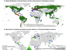
UNESCO biosphere reserves serve as learning areas for sustainable development, where preserving ecosystem functionality is an imperative. However, this critical assumption has yet to be thoroughly examined.
Eliminating invasive rats may restore nutrient flow across food chain networks in Seychelles
Ecosystems are characterized by interconnected structure and functions.
Enabling Pathways for Rights-based Community-led Conservation
The Kunming-Montréal Global Biodiversity Framework (GBF) recognizes that durable conservation outcomes cannot be achieved without the rights, leadership, and knowledge of Indigenous Peoples, Afro-descendant Peoples, and local communities.
Engaging youth in biodiversity education through visual narrative
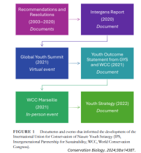
Engaging youth in early and sustained conservation education has important implications for promoting positive attitudes and behaviors in those who will become the future of conservation and management.
Enhanced regional connectivity between western North American national parks will increase persistence of mammal species diversity
Many protected areas worldwide increasingly resemble habitat isolates embedded in human-modifed landscapes. However, establishing linkages among protected areas could signifcantly reduce speciesloss rates.
Enhancing coral bleaching predictive tools through integrating sensitivity to heat exposure
Predicting coral bleaching events has been key to reef conservation management efforts. Current satellite-based bleaching prediction tools offer effective regional-scale alerts of bleaching risk, but lack reliability at the reef-scale.
Enua Manea: Takitumu Conservation Area, Cook Islands
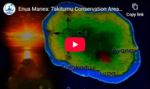
The video showcases the Takitumu Conservation Area in Rarotonga emphasising the collaborative and enduring efforts of local communities, environmental organisations, and conservation practitioners.Call Number: [EL]Physical Description: 20 mins
Environmental Monitoring Guide Series
The Transformative Pathways project has created a series of four guides on environmental monitoring, both for local organisations who are supporting Indigenous Peoples and local communities, and for communities themselves.
Equipping the next generation of plant taxonomists: Insights and recommendations
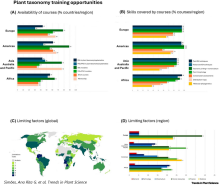
Plant taxonomy underpins biodiversity research and conservation, but global disparities in training and resources hinder progress, especially in biodiversity- rich regions.
Establishing marine protected areas in a changing climate
This guidance aims to inform the planning, design, and implementation of new and expanded MPAs, OECMs, areas conserved by Indigenous peoples, and networks of protected and conserved areas at the community, national, and international levels.
ESTABLISHMENT AND MAINTENANCE OF PROTECTED AREAS IN KADAVU PROVINCE, FIJI DIAGNOSIS AND ACTION PLAN
The Resilience of Ecosystems and Societies to Climate Change (RESCCUE) project is a regional project implemented by the Secretariat of the Pacific Community.
Evaluating the social and ecological effectiveness of partially protected marine areas
Marine protected areas (MPAs) are a primary tool for the stewardship, conservation, and restoration of marine ecosystems, yet 69% of global MPAs are only partially protected (i.e., are open to some form of fishing).
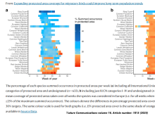
Evidence that spillover from Marine Protected Areas benefits the spiny lobster (Panulirus interruptus) fishery in southern California
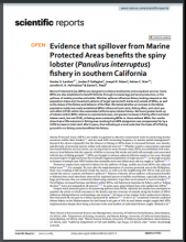
Marine Protected Areas (MPAs) are designed to enhance biodiversity and ecosystem services. Some
MPAs are also established to benefit fisheries through increased egg and larval production, or the
Expanding protected area coverage for migratory birds could improve long-term population trends
Populations of many migratory taxa have been declining over recent decades. Although protected areas are a cornerstone for conservation, their role in protecting migratory species can be incomplete due to the dynamic distributions of these species.
Explainer: Why OECMs are crucial to conserving 30% of Earth’s lands and waters
Places where nature thrives outside of protected areas have huge potential to help the world achieve the global pledge to conserve 30% of Earth’s lands and waters by 2030 A sacred forest in India. A community-managed fishery in the Philippines. A military training ground in Europe.
Fiji Marine Interactive Marine Atlas
While the ocean covers more than two thirds of the Earth’s surface, the oceanic territory of Fiji is 70 times larger than its land territory. With an exclusive economic zone (EEZ) of 1.29 million km 2 , Fiji is a large ocean state.
Fiji National Marine Ecosystem Service Valuation
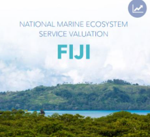
Coastal and marine ecosystems provide a variety of ecological functions1 that directly and indirectly translate to economic services with value to humans.
FINAL REPORT - Seabird Survey of Aleipata Offshore Islands, Samoa. 24-26 October 2022
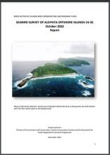
The Aleipata group of offshore islands have been identified as one of eight Key Biodiversity Areas (KBAs) in Samoa. They are located at the south-eastern end of Upolu Island at 14o3’447.28”S, 171o25’23.84”W (Nu’utele) and 14o4’22.11”S and 171o24’36.17”W (Nu’ulua) offshore.
Fisheries Management by Communities. A Manual on Promoting the Management of Subsistence Fisheries by Pacific Island Communities
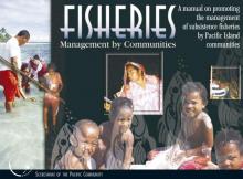
King, M, Lambeth, L. 2000. Secretariat of the Pacific Community, Noumea, New Caledonia.
Five key opportunities to enhance the effectiveness of area-based marine conservation
Effective area-based conservation is central in global efforts to reverse marine biodiversity loss and safeguard ecosystem functioning.
For sharks on the brink of extinction, CITES Appendix II isn’t protective enough (commentary)

Sharks are some of the most threatened animals on Earth, with approximately one-third of all species assessed as threatened with extinction on the IUCN Red List.
Forest Declaration Assessment 2025
Deforestation and degradation rates remained stubbornly high in 2024, pushing the world even further off track from the shared goal of halting and reversing forest loss by 2030.
Forest loss persists despite certification and protection
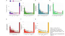
Forest loss is a significant global problem. Forest certification schemes and protected areas are two key approaches for improving forest conservation and management outcomes, but their effectiveness in reducing national-level forest loss remains unclear.
Forest Policy Toolkit: Effectiveness and Political Risks (The Forest-Climate Nexus: A Fit-for-Purpose Framework for Climate Impact)

Acknowledging the diversity of forest contexts and the need for tailored approaches, this chapter examines the policy instruments that can operationalize a differentiated forest-climate agenda to achieve conservation and restoration outcomes.
Forests don’t just store carbon. They keep people alive, scientists say

For decades, a dominant argument for protecting forests has focused on carbon. Trees absorb carbon dioxide, store it in wood and soils, and slow the accumulation of greenhouse gases. A new scientific review suggests this emphasis overlooks other ways forests shape climate and human well-being.
From entry into force to early implementation: Environmental Impact Assessments under the BBNJ Agreement

With the entry into force of the BBNJ Agreement, attention has rapidly shifted from negotiation to the practical realities of implementation.
From local knowledge and science to policy: Lessons learned from Fiji's valuable grouper fisheries
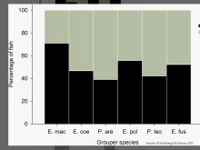
Pacific Island communities are heavily dependent on fisheries for subsistence and livelihoods. Yet, despite their importance, coastal fisheries are poorly managed and commercial pressures increasingly threaten them.
Future-proofing the global system of marine protected areas: Integrating climate change into planning and management
Climate change and its impacts are increasingly threatening the ability of marine protected areas (MPA) to meet their conservation goals.
Gaps and weaknesses in the global protected area network for safeguarding at-risk species
Protected areas are essential to biodiversity conservation.
Gender Responsive Nature-based Solutions
The Gender-responsive Nature-based Solutions (NbS) Toolkit provides a comprehensive framework and practical guidance for integrating gender-responsive strategies into the planning, implementation, and management of NbS. Developed by Arup and Social