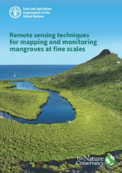
Mangrove ecosystems play a critical role in harbouring biodiversity and providing a variety of ecosystem services. The need for developing better techniques for classifying and monitoring mangroves is increasing, especially with the growing demand in blue carbon markets. However, many countries are challenged by the need to improve their mangrove cover estimates to inform decision-making on coastal land use and to guide local conservation efforts including restoration planning. This manual was developed to help overcome this problem by providing guidance, specifically targeted to build capacity for mangrove resource managers on how to use and take advantage of the latest technologies in mapping and monitoring mangroves. It enables collection of data that informs conservation decision-making, guiding the planning of mangrove restoration and protection activities that will ultimately lead to enhanced management and conservation of mangroves. In addition, case studies are presented on estimating mangrove extent, structure, condition and change, using a range of remote sensing-derived sources that are focused on < 5-m spatial resolution.
Community Synthesis Report - Ecosystem and Socio-economic Resilience Analysis and Mapping (ESRAM) Central Province, Solomon Islands
This publication is a simplified summary version of the report ‘Ecosystem and Socio-economic Resilience Analysis and Mapping (ESRAM) for Central Province, Solomon Islands’.
Community-based Biological Monitoring Training Guide (Applied at FLMMA Project Sites)
Tawake, A., Meo, S., Cakacaka, A. and Aalbersberg, W.G.L. 2004. Institute of Applied Sciences, USP
Community-Based Management
Community Based Management resources
Community-Based Management through Special Management Areas
Community Information Pamphlet; unkown date. Department of Fisheries, Tonga
Community-Based Marine Resource Management in Solomon Islands: A Facilitator’s Guide
WorldFish. 2013. CGIAR Research Program on Aquatic Agricultural Systems. Penang, Malaysia.
Comparing impacts and recovery of locally managed reefs after exposure to extreme waves from a category 5 cyclone
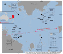
As the climate warms, coral reefs face more frequent and severe impacts from thermal stress while a greater proportion of tropical cyclones are expected to reach the strongest categories.
Comparison of historical (1980s) and contemporary (2023–2024) microplastic contamination of arc clams (Anadara spp.) from tidal flats in Suva, Fiji
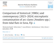
Microplastic pollution threatens marine ecosystems, especially in vulnerable regions like the Pacific Islands. This study examines temporal trends by comparing Anadara spp. specimens from Fiji's tidal flats in the 1980s and 2023–2024.
Conservation and Commerce: Managing Small-Scale Fisheries for Ecological and Livelihood Benefits
Delivering both social and ecological outcomes is regarded as essential for conservation actions to be effective, particularly in regions where Indigenous Peoples (IPs) and local communities (LCs) depend heavily on natural resources.

Conservation Finance for Coral Reefs
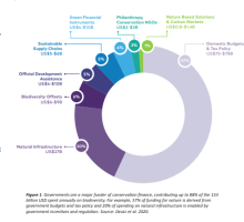
Coral reefs face threats from climate change and local pressures, but many initiatives designed to deliver conservation outcomes for them and the social-economic systems they support are limited by sustainable finance and the availability of funds over the long term.
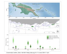
Conservation Imperatives: securing the last unprotected terrestrial sites harboring irreplaceable biodiversity
Ambitious biodiversity goals to protect 30% or more of the Earth’s surface by 2030 (30x30) require strategic near-term targets.
Conserving our sea of islands State of protected and conserved areas in Oceania
Conserving our sea of islands: State of protected and conserved areas in Oceania report is the first comprehensive regional assessment of protected and conserved areas.
Convention on Biological Diversity – Protected Areas Management Effectiveness
Convention on Biological Diversity – Protected Areas Management Effectiveness
Cook Islands State of Environment (SOE) report
The 2018 SOE is a new baseline for future reports and can help the Cook Islands with national regional and international reporting obligations including multi-lateral environmental agreements.Available onlineCall Number: 333.7209623 COO, [EL]ISBN/ISSN: 978-982-04
Cook Islands GEF 7 Project Documents & Reports
Official project document for the Cook Islands national project under GEF-7 programming, project title: Enhancing Biodiversity considerations and effective protected area management to safeguard the Cook Islands integrated ecosystems and species. Annexes not in
Cook Islands GEF-7 Project ENUA Documents & Reports

This project aims to reduce and mitigate negative environmental impacts of the key development sectors (agriculture, infrastructure, tourism), which were recognized in the 2018 State of Environment Report as the main national drivers of biodiversity and habitat degradation.The Cook Islands GEF-7
Coral Health and Disease in the Pacific: Vision for Action
Galloway, S.B., Bruckner, A.W. and Woodley, C.M. (eds.). Coral Health and Disease in the Pacific: Vision for Action. 2009. NOAA Technical Memorandum NOS NCCOS 97 and CRCP 7.
Coral microbiomes as reservoirs of unknown genomic and biosynthetic diversity

Coral reefs are marine biodiversity hotspots that provide a wide range of ecosystem services1.
COVID-19 and protected areas: Impacts, conflicts, and possible management solutions
During the first wave of the COVID-19 pandemic, management authorities of numerous Protected Areas (PAs) had to discourage visitors from accessing them in order to reduce the virus transmission rate and protect local communities.
COVID-ERA POLICIES AND ECONOMIC RECOVERY PLANS: ARE GOVERNMENTS BUILDING BACK BETTER FOR PROTECTED AND CONSERVED AREAS?
The COVID-19 pandemic is having a major impact on conservation policies and practice at multiple scales, including protected and conserved areas (PCAs). There is a need to understand the implications for PCAs of recent actions, enacted or promoted in the wake of COVID-19.
Creating a National Coral-Focused Climate Change Adaptation Plan for Fiji to Prevent Coral Species Extinction in the Face of Rapid Climate Change: Applying the UNESCO-Endorsed “Reefs of Hope” Ocean Decade Action
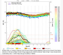
In the face of recent setbacks to coral reef conservation and restoration due to intensifying marine heat waves, new coral-focused strategies have been developed to accelerate natural processes of coral reef adaptation and recovery.
Cultural ecosystem services and the conservation challenges for an Indigenous people's aquatic protected area practice.
Globally, protected areas associated with sacred sites and cemeteries are an emerging area of research. However, they are biased toward terrestrial systems.
Current Recorded Cook Islands Terrestrial Protected Areas. (NES 2011)
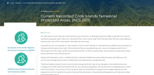
The SOE uses the 2011 report by Cook Islands to the Convention on Biological Diversity (CBD) to identify the country’s terrestrial protected areas.
Current trends and future directions for integrating social values into mangrove restoration
Despite the recent rise in mangrove restoration projects, the extent to which many projects include social dimensions remains contested, with limited research informing insights from on-ground projects.
Database of Global Data Sources for Biodiversity Conservation Monitoring

Here you can access a database created by the Group in collaboration with Re:wild as part of an inventory of available data sources.
Decent Work in Nature-Based Solutions 2024: Unlocking jobs through investment in skills and nature-based infrastructure
This report – the second in a series of International Labour Organization (ILO)–United Nations Environment Programme (UNEP)–International Union for the Conservation of Nature (IUCN) publications on decent work in nature-based solutions (NbS) – aims to improve the understanding of the role of NbS
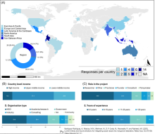
Defining ‘science-based targets’
Setting targets for addressing major planetary concerns is an essential prerequisite for concerted global action (both inside and outside multilateral environmental agreements) and is necessarily a societal and political process, requiring negotiation and convergence among oftenconflicting intere
Delimiting Surveys for Invasive Ants
Pacific Invasives Network. Delimiting Surveys for Invasive Ants. 2013. Auckland, New Zealand.
Designing and managing protected and conserved areas to support inland water ecosystems and biodiversity
Inland waters – such as rivers, lakes and other wetlands – are among the most biodiverse ecosystems on the planet. They are also the most threatened; almost one in three species is at risk of extinction and monitored populations of freshwater species have declined by 85% since 1970.
Designing gender-inclusive data systems in small-scale fisheries
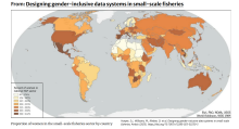
Gender equality is a ubiquitous national goal, yet sectoral gender data gaps to support this goal persist.
Devastation of island biodiversity: a land snail perspective

Many islands are remote and the level of interest in land snails as a component of the global biodiversity conservation agenda is low. The conservation status of many island land snail faunas thus remains at best out of date.
Documenting biodiversity outcomes in marine fisheries management
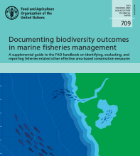
This guidance suggests actionable ways fisheries managers can utilize the types of survey and monitoring data generally being collected in priority areas (i.e.
Downlisting and recovery of species assessed by the IUCN
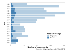
Despite the increasing number of species assessed for extinction risk by the International Union for Conservation of Nature (IUCN) (163,040 species as of 2024), only about 1 in 1,000 have been downlisted due to genuine population improvement.
Draft for Discussion : Issues for consideration in the development of a Marine Protected Area Policy for Papua New Guinea
Papua New Guinea is a Member of the Coral Triangle Initiative on Coral reefs, Fisheries and Food Security (CTI-CFF), and in order to support the marine biodiversity goals of the CTI Regional and National Plans of Action, one action they have prioritised, is the need to strengthen marine governanc
Draft Marine Bioregions of the Southwest Pacific
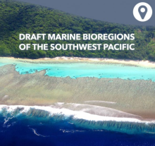
Marine spatial planning is underway now, or starting, in many Pacific Island countries.
ECOLOGICAL AND SOCIOECONOMIC VULNERABILITY AND OPPORTUNITIES ASSESSMENT (ESVOA) SOUTH WEST BAY, MALEKULA
The objective of an Ecosystem and Socio-economic Resilience Analysis and Mapping (ESRAM) process is to generate a robust planning baseline to inform the identification of ecosystem-based adaptation (EbA) options for strengthening the socio-ecological resilience of communities to the impacts of cl
Ecological and Socioeconomic Vulnerability and Opportunities Assessment (ESVOA), North Pentecost
The objective of an Ecosystem and Socio-economic Resilience Analysis and Mapping (ESRAM) process is to generate a robust planning baseline to inform the identification of ecosystem-based adaptation (EbA) options for strengthening the socio-ecological resilience of communities to the impacts of cl
Ecological and Socioeconomic Vulnerability and Opportunities Assessment (ESVOA), Tenmaru, Malekula
he objective of an Ecosystem and Socio-economic Resilience Analysis and Mapping (ESRAM) process is to generate a robust planning baseline to inform the identification of ecosystem-based adaptation (EbA) options for strengthening the socio-ecological resilience of communities to the impacts of cli
Ecological and Socioeconomic Vulnerability and Opportunities Assessment (ESVOA), Wiawi, Malekula.
The objective of an Integrated Ecosystem Management Plan process is to generate a robust planning baseline to inform the identification of ecosystem-based adaptation (EbA) options for strengthening the socio-ecological resilience of communities to the impacts of climate change and other direct an
Ecological functional diversity predicts nutritional functional diversity in complex agroforests
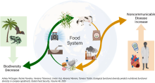
Biodiversity loss and rising noncommunicable disease incidences are among the greatest global challenges we face.
Ecosystem and Socio-Economic Resilience Analysis and Mapping (ESRAM) : Solomon Islands, Vol 3 : Honiara
This report Volume 3 (of three volumes) prepared as part of the Solomon Islands Ecosystems and Socio-economic Resilience Analysis and Mapping (ESRAM) to assess and priortise climate change-related ecosystem-based adaptaton options for selected locations in Solomon Islands.
Ecosystem and socio-economic resilience analysis and mapping (ESRAM) : Solomon Islands, Volume 1 : introduction and national assessment
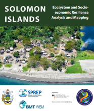
This report presents Volume 1 (of three volumes) prepared as part of the Solomon Islands Ecosystems and Socio-economic Resilience Analysis and Mapping (ESRAM) to assess and prioritise climate change-related ecosystem-based adapation options for selected locations in Solomon Islands.
Ecosystem and socio-economic resilience analysis and mapping (ESRAM) : Solomon Islands, Volume 2 : Wagina Island (Choiseul Province)
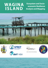
This report presents Volume 2 (of three volumes) prepared as part of the Solomon Islands Ecosystems and Socio-economic Resilience Analysis and Mapping (ESRAM) to assess and climate change-related ecosystem-based adaptation (EbA) options in Solomon Islands.
Ecosystem and Socio-economic Resilience Analysis and Mapping (ESRAM) for Central Islands Province, Solomon Islands
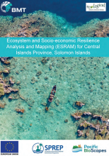
The target area for the ESRAM assessment is the land- and seascape comprising Nggela Islands, Russell Islands and Savo Island. This is largely due to the very high biodiversity values of their terrestrial and marine areas.
Ecosystem and Socio-economic Resilience Analysis and Mapping (ESRAM) for Central Islands Province, Solomon Islands
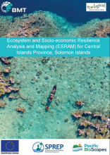
The target area for the ESRAM assessment is the land- and seascape comprising Nggela Islands, Russell Islands and Savo Island. This is largely due to the very high biodiversity values of their terrestrial and marine areas.
Ecosystem and Socio-economic Resilience Analysis and Mapping (ESRAM) for three Communities of Southern Malaita & Maramasike Passage, Solomon Islands : Summary Report
This report presents a summary of an Ecosystem and Socio-economic Resilience Analysis and Mapping (ESRAM) project in three communities in South Malaita, Malaita Province in the Solomon Islands; Tapa'atewa, Eliote and Ori Pre.
Ecosystem and socio-economic resilience analysis and mapping Macuata Province Fiji
The ecosystem and socio-economic resilience analysis and mapping (ESRAM) is a baseline study to identify vulnerabilities in ecosystem services at national, provincial and community scales in Fiji.
Ecosystem and socio-economic resilience analysis and mapping Taveuni Island, Fiji
The ecosystem and socio-economic resilience analysis and mapping (ESRAM) is a baseline study to identify vulnerabilities in ecosystem services at national, provincial and community scales in Fiji.
Ecosystem and Socioeconomic Resilience Analysis and Mapping Navua catchment and Beqa lagoon 2024
This report presents the Ecosystem and Socioeconomic Resilience Analysis and Mapping (ESRAM) prepared as part of Objective 4. ESRAM is a framework employed globally to evaluate and strengthen the resilience of both, natural ecosystems and the socioeconomic systems closely linked to them.
Ecosystem-based adaptation options assessment - Macuata province Fiji
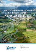
This project identifies two Ecosystem-based Adaptation (EbA) options that are organisational tools to strengthen the ability of the Government of Fiji to manage for the resilience and diversity of ecosystem services over time.


